City Map
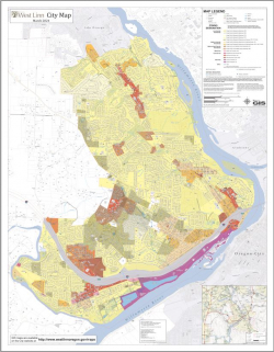
The City Map displays general zone designations throughout the City and is for general reference only. This map is not considered the official zoning map for the City of West Linn and there may be zoning changes that have occurred since the publication of this map in March 2024. Use the link below Supporting Documents to download a printable 42"x54" PDF map.
Do you have questions about the zoning of your property?
Contact the West Linn Planning Department:
https://westlinnoregon.gov/planning/planning-contact-information
Please check with the West Linn Planning Department for adopted land-use source documents for specifics on individual locations. Link to Planning Department: http://westlinnoregon.gov/planning
Please see the Community Development Code for more information about zoning in West Linn: http://westlinnoregon.gov/cdc
GIS Standard Map Disclaimer:
This product is for informational purposes and may not have been prepared for, or be suitable for legal, engineering, or surveying purposes. Users of this information should review or consult the primary data and information sources to ascertain the usability of the information.
This map is also available in printed format for public viewing at West Linn City Hall, at the Building/Engineering/Planning counter on the 1st floor.
For the most up-to-date general zone designations, please also visit the City's interactive web map, West Linn Maps: https://westlinnoregon.gov/maps/west-linn-maps

